
Air Pollution Exposure Simulation
The main function of the Pollution Exposure Simulation Module is to simulate atmospheric pollutant concentrations and population exposure levels under different future scenarios. This module mainly consists of two components: a climate–chemistry interaction assessment system and an atmospheric chemistry simulation system. Based on future atmospheric species emissions provided by the Emission Pathway Simulation Module, the climate–chemistry interaction assessment system is used to assess the two-way feedbacks between meteorological variables and atmospheric composition under future climate change. The atmospheric chemistry simulation system is then used to simulate changes in atmospheric pollutant concentrations and population exposure levels under different scenarios. To reduce the influence of model errors, the module uses atmospheric composition concentration data from the Tracking Air Pollution (TAP) to calibrate the simulation results.
The climate–chemistry interaction assessment system uses dynamic downscaling techniques to link CMIP6 multi-model simulation results with the online coupled climate–chemistry model WRF-Chem. CMIP6 simulation results are used as the meteorological initial fields to drive WRF-Chem, enabling assessment of the impacts of climate change on air quality, as well as the feedback effects of atmospheric composition changes on meteorological variables.
The core of the atmospheric chemistry simulation system is the atmospheric chemical transport model. Depending on the research target and scientific objective, the system uses atmospheric chemical transport models such as GEOS-Chem, WRF-CMAQ, and WRF-Chem. To improve simulation efficiency, the team has developed the CleanAir Model based on artificial intelligence and the WRF-CMAQ model, supporting rapid simulation of daily PM2.5 and its chemical component concentrations. The simulation system uses anthropogenic emissions under different scenarios provided by the Emission Pathway Simulation Module as inputs to simulate future changes in atmospheric pollutant concentrations and population exposure levels.
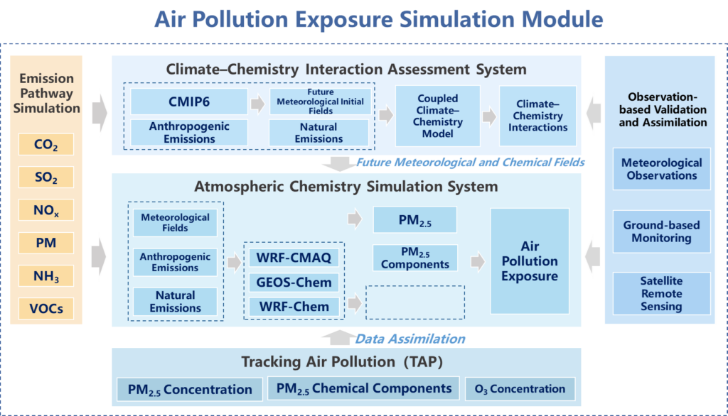
Figure 1. Technical framework of the Pollution Exposure Simulation Module
The CleanAir Model>
The CleanAir Model is a large model developed by the CNCAP team at Tsinghua University for PM2.5 pollution control in China. The model can rapidly simulate the responses of PM2.5 and its chemical component concentrations to changes in precursor emissions, including SO2, NOx, PM2.5, PM10, NH3, VOCs, BC, and OC. The model adopts a residual 3D U-Net deep neural network architecture and is trained using a daily emission-reduction scenario dataset generated by the WRF-CMAQ model. It covers the whole of China at a horizontal resolution of 36 km.
The CleanAir Model achieves simulation accuracy close to that of the CMAQ model while improving computational efficiency by more than 40,000 times. It substantially reduces computational costs and enables large-scale and diverse emission reduction scenario simulations, overcoming the limitations of high cost and low efficiency in traditional models. Version 1 of the CleanAir Model has now been deployed online. For more details and user instructions, please refer to the model introduction and user guide.
Reference:
- Liu, S., Geng, G., Xiang, Y., Hu, H., Liu, X., Huang, X., Zhang, Q. A deep-learning model for predicting daily PM2.5 concentration in response to emission reduction. arXiv:2506.18018. [Link]
GEOS-Chem Model>
GEOS-Chem is an open-source global three-dimensional atmospheric chemical transport model developed by the research group of Professor Daniel Jacob at Harvard University. It uses assimilated meteorological data from the Goddard Earth Observing System (GEOS), provided by the Global Modeling and Assimilation Office of the National Aeronautics and Space Administration (NASA), as meteorological fields to simulate atmospheric chemical and physical processes at global and regional scales. GEOS-Chem also provides a nested version for China, enabling simulations at higher spatial resolution. For detailed information and code download, please refer to the GEOS-Chem website.
WRF-Chem Model>
WRF-Chem was developed by the Earth System Research Laboratory (ESRL) of the U.S. National Oceanic and Atmospheric Administration (NOAA). It is a regional air quality model formed by online coupling of the Weather Research and Forecasting model (WRF) and the chemistry model Chem. Through online coupling, WRF-Chem simulates atmospheric physical and chemical processes, and can represent interactions between atmospheric composition and meteorological conditions, including aerosol–radiation interactions and cloud–radiation interactions. For detailed information and code download, please refer to the WRF-Chem website.
CMAQ Model>
The Community Multiscale Air Quality Modeling System (CMAQ) is a third-generation air quality modeling system developed by the U.S. Environmental Protection Agency. Driven by the mesoscale meteorological model WRF, CMAQ simulates various complex physical and chemical processes in the atmosphere, including pollutant transport, diffusion, deposition, and meteorological, aqueous-phase, and heterogeneous chemical reactions. CMAQ has been widely used in scientific research and operational applications, including air pollution process analysis, air quality forecasting and early warning, and air quality attainment planning. For detailed information and code download, please refer to the CMAQ website.
Tracking Air Pollution(TAP)>
To reduce simulation errors in atmospheric chemistry models, the Pollution Exposure Simulation Module uses the Tracking Air Pollution (TAP) to conduct assimilation-based calibration of future-year simulation results. Atmospheric chemistry models are used to simulate the relative changes in atmospheric composition concentrations between future years and the baseline year. These relative changes are then combined with baseline-year atmospheric composition concentrations obtained from the TAP dataset to derive atmospheric composition concentrations for future years.
The TAP dataset is developed and maintained by Tsinghua University. By integrating multiple data sources, including ground-based observations, satellite remote sensing, emission inventories, and model simulations, TAP uses machine learning algorithms to construct a multi-scale, near-real-time dataset of atmospheric aerosol and gaseous pollutant concentrations in China, and shares these data products with the scientific community through a cloud-computing platform.
For detailed information about the TAP dataset and data download methods, please refer to the official TAP website. Currently, the TAP dataset provides downloadable data including daily concentrations of fine particulate matter and major chemical components in China at 10 km resolution from 2000 to the present, daily fine particulate matter concentrations in China at 1 km resolution from 2000 to the present, and daily near-surface ozone concentrations in China from 2013 to the present.
References:
- Geng, G., Xiao, Q., Liu, S., Liu, X., Cheng, J., Zheng, Y., Xue, T., Tong, D., Zheng, B., Peng, Y., Huang, X., He, K., & Zhang, Q. (2021). Tracking Air Pollution in China: Near Real-Time PM2.5 Retrievals from Multisource Data Fusion. Environ Sci Technol, 55, 12106-12115. [Link]
- Xiao Q, Geng G, Liu S, Liu J, Meng X, Zhang Q. Spatiotemporal continuous estimates of daily 1 km PM 2.5 from 2000 to present under the Tracking Air Pollution in China (TAP) framework. Atmospheric Chemistry and Physics. 2022 Oct 14;22(19):13229-42. [Link]
- Liu S, Geng G, Xiao Q, Zheng Y, Liu X, Cheng J, Zhang Q. Tracking daily concentrations of PM2.5 chemical composition in China since 2000. Environmental Science & Technology. 2022 Nov 1;56(22):16517-27.[Link]